Distance: 5.4 miles / 8.7 kilometres
Total ascent: 95 feet / 29 metres
Walking time: 2 to 2.5 hours
Retrace your steps to Bevington Substation. At the far-left (north-west) corner of the enclosure, turn right onto the gravel track. Follow the track downhill for 900 metres, at which point it becomes a tarmacked lane and passes to the right of two houses. Follow the lane around a sharp righthand bend and then for 500 metres more. Keep to the left of a small pond surrounded by trees and shortly before coming to a white house (on your left), enter the field on your right through a gate.
Follow the footpath across the fields for 1.1 km as it passes to the right of a larger tree-lined pond and then becomes a lane serving several houses. Where the lane joins a road at the hamlet of Rushford, cross over the B4088 and follow the footpath opposite. This path runs eastwards for 150 metres, next to some trees on your left, before turning a little to the right and heading south-eastwards across the fields. At the fork in the paths after 170 metres, take the righthand way. 770 metres further on, after passing two houses on your right, take a sharp left at the bottom of a field. Continue following the path for 380 metres as it curves right, crosses a brook via a footbridge and then intersects another footpath. Beyond the next hedge, turn left and walk past the polytunnels of a large fruit farm called The Orchards.

Before reaching the modern housing of Salford Priors, the path turns right and takes you around the perimeter of The Orchards. Ignore the main driveway on the east side of the farm (leading north-eastwards to School Road) and instead walk around the south side and take the footpath past the Orchards School of Cookery to Evesham Road. Upon reaching Evesham Road after 400 metres, turn right and keep to the footpath on the righthand (north) side of the road.

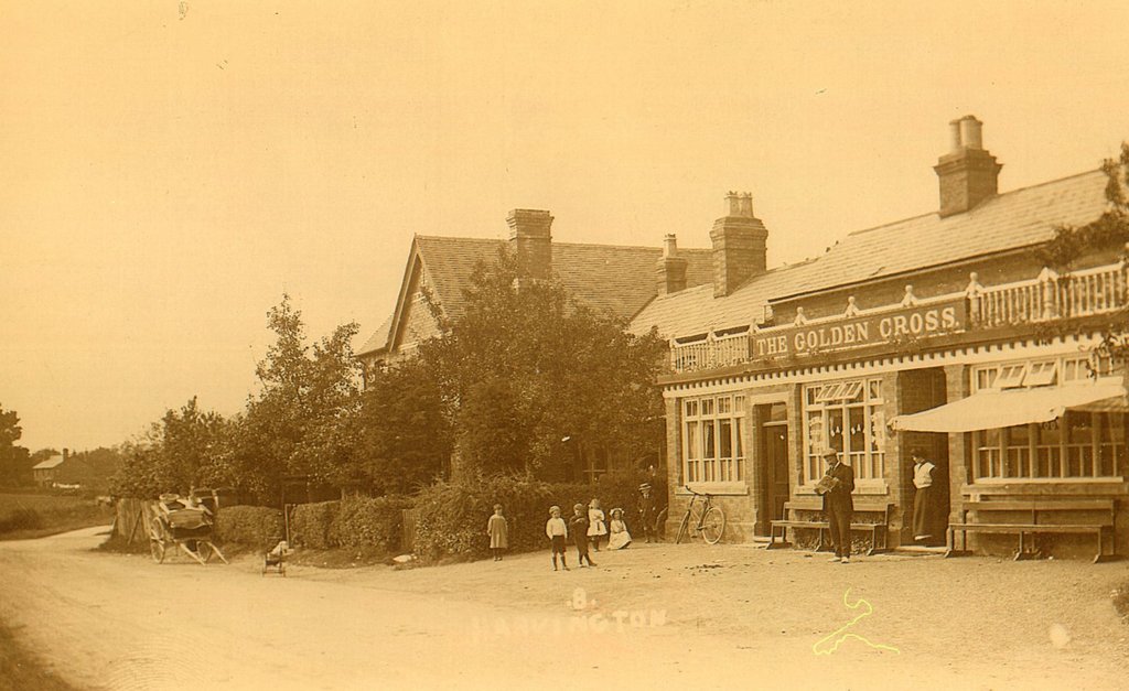
Walk along Evesham Road for 2.2 km (1.4 miles), passing through Abbot’s Salford and then reaching Harvington. As you approach the east side of Harvington, turn right onto Crest Hill and walk up the road for 400 metres. At the car park of The Coach and Horses Inn, turn right onto Station Road and proceed for 350 metres. Where Station Road meets Village Road, turn right and follow the latter for 400 metres as far as the pub called The Golden Cross at the north end of Harvington. This is the end of the alternative Leg 3B and a good place to stop for a drink.
The Golden Cross in Harvington has some interesting elements in common with Tolkien’s fictional The Golden Perch, a pub in the Hobbit village of Stock which Pippin says produces the best beer in the Eastfarthing. Not only do the inns occupy similar locations in relation to river, road and hills, but the latter name could be seen as a pun on the former. Another word for ‘cross’ is ‘rood’, which is also an old English measurement of area (equal to a quarter of an acre), and there are forty ‘perches’ in a rood.
It’s not inconceivable that Tolkien patronised The Golden Cross at some point, for Harvington lies only three miles north of Blackminster. He may have stopped there while visiting Hilary (in the years when a ferry at The Fish & Anchor Inn connected the two villages), or perhaps when travelling to or from Dormston or Birmingham. However, I have seen no textual evidence for this.
The building that houses The Golden Cross was constructed in the 1830s. Perhaps originally a tollhouse or farmhouse, it had become an inn by 1841. At some stage a single-storey extension was added to the front, along with a now missing balustrade. By 1911, the innkeeper was Samuel Coley, who supposedly profited during the First World War from the Defence of the Realm Act. This legislation restricted the sale of alcohol for considerable distances around munitions factories, including one in Redditch, twelve miles to the north of Harvington. Being sited just outside the limits of an area where only watered-down beer could be served, The Golden Cross attracted many more customers from the north than it otherwise might have.
