The Moseley Ring is a circular walking route in south Birmingham, distinct from the long-distance component of The Shire Way. Its waypoints relate entirely to the family and early biography of J.R.R. Tolkien, including the first four places in England that he called home. By walking the route in a counter-clockwise direction you’ll visit these locations in the order in which he lived in them between the ages of 3 and 10.
Distance: 9.75 miles / 15.69 kilometres
Total ascent: 364 feet / 111 metres
Walking time: 3 to 4 hours
The walk starts from King’s Heath High Street (also known as the A435 Alcester Road), outside the railway station that is currently under construction and scheduled to open in 2025. Cross over the road and walk up Valentine Road, which joins the High Street opposite the station entrance. After 30 metres take the first left turn onto Ashfield Avenue. Walk 150 metres up Ashfield Avenue.
On your left is 9 Ashfield Avenue, which was the home of J.R.R. Tolkien’s school-friend Sidney Barrowclough, according to the 1911 Census. Barrowclough, whose father managed a rubber works, was one of the younger members of the T.C.B.S..

Follow Ashfield Avenue around to the right and continue for 170 metres to the junction with Ashfield Road. Turn right and walk 100 metres downhill.
On the right is 9 Ashfield Road, until 1904/5 the home of Tolkien’s maternal grandparents, John and Emily Suffield, and his first residence in England. Tolkien lived here with his mother and brother for over a year following their arrival from South Africa in April 1895. Being only three years old at the time, he had difficulty differentiating this house from his home in Bloemfontein: ‘I can still remember going down the road in
Birmingham and wondering what had happened to the big gallery, what happened to the balcony…’ News of the death of Tolkien’s father in February 1896 would have reached the family by telegram at 9 Ashfield Road.

Continue down Ashfield Road for a further 60 metres to the junction with Valentine Road.
The third house on your right (35 Valentine Road) occupies the site of a house where a first cousin of Tolkien’s mother lived, according to the 1911 Census. William Arthur Marris (1868-1939) was the doctor for the local area.
Turn left and walk 150 metres to the roundabout where five roads meet.
On your left is 67 Valentine Road, the building which housed the surgery of Tolkien’s relation, Dr William A. Marris.

At the roundabout, continue straight across to Springfield Road (the second road from the right). Walk 200 metres and take Melton Road, which forks right at the mini-roundabout, and then take the first right onto Heathfield Road. Continue to the end of Heathfield Road, where it meets King’s Heath High Street. Turn left and walk 80 metres to the junction with Institute Road.
The unprepossessing shops on your left (which, in 2024, include a Costa Coffee) occupy the site of the King’s Heath Institute, where Tolkien’s mother and aunt attended a party in September 1895, according to research by the scholar Maggie Burns.
Continue southwards along the High Street for 20 metres and use the crossing to reach the west side of the street. Having crossed, keep going in a southerly direction for around 30 metres, until you are standing outside the church.
All Saints’ Church was the venue for the wedding of Tolkien’s paternal grandparents on 16th February 1856. John Benjamin Tolkien was 48 years old at the time; his bride, Mary Jane Stow, was 22. (On the opposite side of the road is the present-day site of one of Tolkien’s first Roman Catholic churches, St Dunstan’s.)

Continue southwards for 50 metres to the busy T-junction.
Across the road and to your right is 2 All Saints Road, where another cousin of Tolkien’s mother, Mary Hamilton Marris (1865-1914), lived and ran a school, according to the 1911 Census.
Begin the 2.5-km walk (1.5 miles) down to Sarehole, the place in the West Midlands most commonly associated with Tolkien. At the T-junction, first use the crossing to traverse Vicarage Road. Then, turn left and cross back over the High Street, allowing you to take the next left, Drayton Road. Continue for 300 metres to the end of Drayton Road and then turn right onto Goldsmith Road. At the end of Goldsmith Road turn left onto Addison Road and walk eastwards for 350 metres to the crossroads at the south-west corner of Moseley Golf Club. Continue straight for around 500 metres, along what has become Brook Lane, to the large roundabout overlooked by a pub called The Billesley. Again, go straight over the roundabout (taking the second road from the left) and continue for another 500 metres along Brook Lane to the roundabout at the junction with Yardley Wood Road. Follow the sign in the middle of the roundabout ‘to Stratford’ and keep going straight down Brook Lane for a further 450 metres, before turning right onto Colebourne Road. Walk down Colebourne Road for 230 metres and follow it as it bends to the right, at which point take the passageway immediately on your left, between 48 and 50 Colebourne Road. Once on this footpath, do not deviate into the meadow on the right but stick to the tarmac path for 100 metres. At the end of the footpath, follow Coleside Avenue around to the left.
Although renovated in recent times, Tolkien would probably still recognise The Four Arches Bridge on your right, which was originally constructed around 1820.
Follow Coleside Avenue northwards for 130 metres to its junction with the A4040 Brook Lane and use the crossing on the left. On reaching the north side of Brook Lane, turn right. Within 30 metres go through the archway on your left and take the John Morris Jones walkway, which runs alongside the River Cole. Follow the footpath through the wooded Shire Country Park for 190 metres to the point where it bends right for the first time.
Beyond the houses on your left is the site of Sarehole Farm. In the late 1890s, its medieval timber-framed farmhouse was home to Arthur Purser, whom Tolkien and his brother Hilary called ‘The Black Ogre’ after he caught them picking mushrooms on his land. Purser’s wife, Alice (née Burgoyne), was the daughter of a local farmer who was under five foot tall and whose surname had originally been Buggins. Sadly, the farmhouse was pulled down in the 1930s.
Continue on the footpath for a further 400 metres until it reaches Cole Bank Road. Use the crossing on the left to reach Sarehole Mill via its car park on the other side of the road.
Tolkien said that Sarehole Mill, on your left, ‘dominated’ his childhood and described it as ‘an old mill that really did grind corn with two millers’; ‘the old miller of my day and his son were characters of wonder and terror to a small child’. A corn mill has existed on the site since the mid-16th century and it’s sometimes claimed that the rustic ‘old mill’ in The Lord of the Rings is based on Sarehole. However, the mill had been re-built in the 18th century and, by Tolkien’s time, used a noisy steam engine and smoking chimney to grind metal as well as corn. Sarehole therefore more closely resembles Ted Sandyman’s expanded ‘new mill’, described in ‘The Scouring of the Shire’ as brick-built and ‘full o’ wheels and outlandish contraptions’.

From the north side of the Sarehole Mill car park, cross the footbridge over the mill race, enter the park and turn left. Walk 150 metres westwards across the grass to the gateway onto Wake Green Road.
This area of grass was the meadow between the River Cole and Tolkien’s home where he and his brother often played. They enjoyed climbing a willow overhanging the mill-pool on the left, until one day the tree was cut down. He later told his biographer: ‘They didn’t do anything with it: the log just lay there. I never forgot that.’
Upon reaching the road, turn right and walk 30 metres (as far as the driveway to Millmead Lodge) before crossing Wake Green Road.
In front of you is 264 Wake Green Road, known to Tolkien as 5 Gracewell Cottages and his home between the summer of 1896 and autumn 1900. In an interview, Tolkien described ‘a row of extremely nice-looking semi-detached cottages, in which [a local solicitor] mostly seemed to have housed his gardeners’. The surroundings were very different at that time: ‘I lived in childhood in a cottage on the edge of a really rural country – on the borders of a land and time more like… the lands and hills of the most primitive and wildest stories than the present life of Western Towns…’ It was the rusticity of Sarehole that made the house affordable to his mother, who was priced out of the more suburban areas inhabited by other branches of the Tolkien and Suffield families.

Of Tolkien’s domestic routine in this cottage, we know that there was an attempt to teach him the violin and, more fruitfully, a great deal of reading. His lifelong interest in languages and the origins of words was kindled by the books he read here and by a remark his mother made ‘when [he] was about seven’. She ‘pointed out that one could not say “a green great dragon”, but had to say “a great green dragon”’. When Mabel Tolkien found it necessary to give up the cottage in 1900, it may have been a comfort to her boys that they could occasionally return, for the lease was taken up by Mabel’s younger brother and his wife, William and Beatrice Suffield.
Turn left and walk 30 metres back down Wake Green Road, then turn right onto Thirlmere Drive. After 180 metres, turn right onto Pensby Close and walk 50 metres uphill. Take the lefthand branch of that cul-de-sac and continue past the row of bungalows to take the footpath on your right, which leads into the woods of Moseley Bog.
Straight ahead of you is the Moseley Bog nature reserve. Once the site of a mill-pond, the area was drained in the 1850s and left to vegetate. By Tolkien’s time it had become ‘a wonderful dell with flowers’. He and Hilary called it Bumble Dell on account of the abundance of blackberries (known locally as ‘bumbles’).

Read the information board located at the entrance to Moseley Bog and then follow the yellow route marked on the map. Once inside the woods, walk down the steps and turn right. Cross Coldbath Brook and then follow the raised wooden walkway to the left. Proceed along the duckboards on the right bank of the brook for 180 metres, at which point it is necessary to keep right at a fork in the walkway. After a further 120 metres, the route bends left and passes a notably large and ancient oak tree in a clearing to your right. From here, follow the main gravel path westwards (i.e. not up the embankment) as far as the car park at the north-west corner of Joy’s Wood, with its elaborate metal gateway. Emerge from the car park and cross to the opposite side of Yardley Wood Road; then turn right and walk 300 metres uphill. Turn left onto St Agnes Road, which bends to the right of the church after 200 metres. Continue northwards along St Agnes Road for a further 450 metres to its junction with Wake Green Road.
Straight ahead is the former site of a house called ‘Abbotsford’ or 69 Wake Green Road, in the 1911 Census the home of Tolkien’s paternal aunt Mabel Mitton (1858-1937). She was one of the relations with whom Tolkien was close and he used Abbotsford as his forwarding address while recuperating from trench fever in late 1916. His brother seems to have stayed there while doing his army training in 1915.
Turn left onto Wake Green Road for 100 metres, before taking the next right onto Belle Walk. Follow Belle Walk as it slopes gently downhill and turn left at its end, keeping parallel to Yardley Wood Road for 100 metres.
On the right is 64 Yardley Wood Road, the former site of ‘Firfield’, the house where Tolkien’s maternal great-grandfather lived between c. 1867 and his death in 1891. It was the venue for many Suffield family gatherings, including Christmas festivities and theatrical performances. An 1880 photo of the family in the garden features Tolkien’s mother as a ten-year-old girl.
A little further on the right is 58 Yardley Wood Road, the site of ‘Mayfield’, the house of Tolkien’s grandfather in the early 1870s. Records list Mabel Suffield’s birthplace as ‘Yardley’ and so it is probable that Tolkien’s mother was born here in 1870. Indeed, ‘Mayfield’ may even be a contraction of her own name. Sadly, neither Firfield nor Mayfield have survived.
Turn left onto Woodstock Road and proceed for 180 metres.
On the left is 64 Woodstock Road, in the 1911 Census the house of a cousin of Tolkien’s grandfather, Joseph Willey Suffield (1855-1919). In 1914, his daughter Maud (who also lived in this house) achieved a reconnection with the family’s past by marrying a printer from Evesham.
After walking a further 130 metres along Woodstock Road, turn left at the traffic lights and follow Anderton Park Road uphill for 200 metres, crossing over the mini-roundabout in the process. Turn right onto Sandford Road and continue for 300 metres. At the junction with Church Road, turn left.
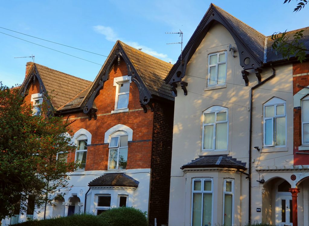
On your left is 53 and 55 Church Road, formerly numbers 16 and 15 respectively. From the late 1880s to c. 1900, 55 Church Road was the house of J.R.R. Tolkien’s paternal grandmother, Mary Jane Tolkien (1833-1915), as well as his uncles Wilfrid and Laurence. At the time of the 1891 Census, the family of Tolkien’s aunt Mabel Mitton was living next door to her mother and brothers at what is now no. 53. The author’s grandfather was still alive but apparently residing with a daughter from his second marriage in Erdington (a north-eastern suburb of Birmingham), where he would die in 1896.
Continue up Church Road for 280 metres to the crest of the hill, where it intersects with Forest Road and Woodbridge Road. Turn right at the crossroads onto Woodbridge Road and, once over the railway bridge, take the next right onto Trafalgar Road and continue downhill for 270 metres.
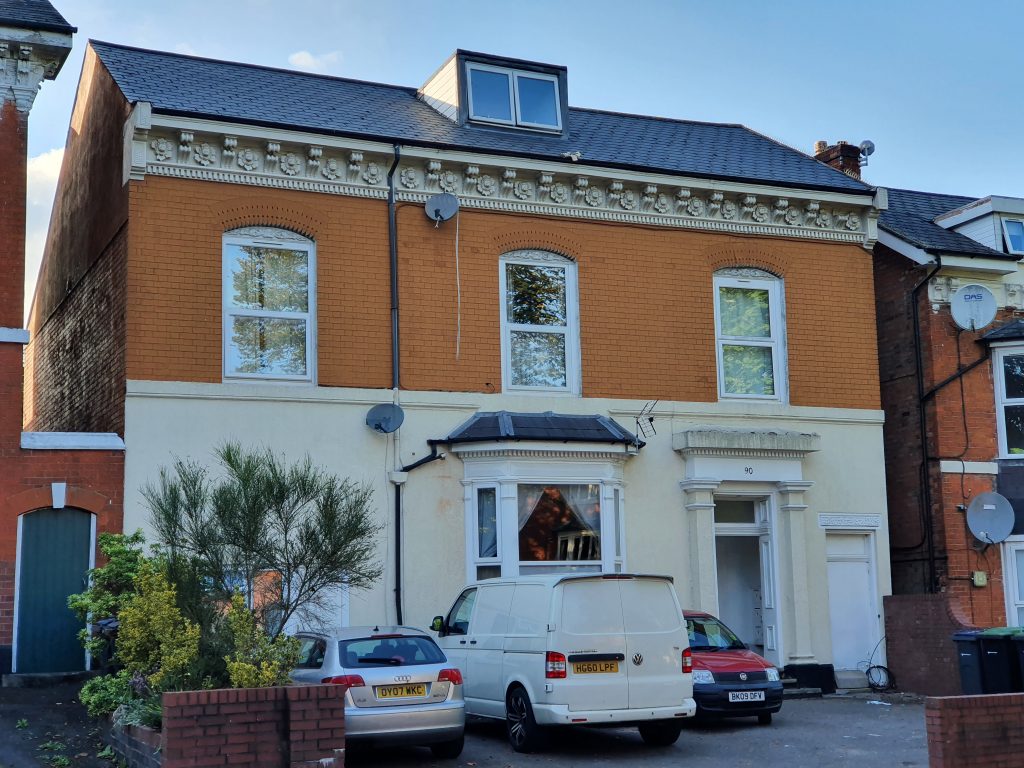
On the left is 90 Trafalgar Road or ‘Malvern House’, which was the residence of John and Emily Suffield in both the 1881 and 1891 censuses and therefore the main childhood home of Tolkien’s mother. It would have been here that Mabel Suffield (1870-1904) was educated (perhaps by a governess as Burns suggests but also by her father) in French, German, Latin, English literature, botany, calligraphy and painting. One of her artworks from 1883 depicts her eldest brother sitting on a bench with a girl, probably in the garden of Malvern House, with the caption ‘Faint heart never won fair lady’. J.R.R. Tolkien would later use one of Mabel’s childhood sketchbooks for his own drawings and paintings.
Continue for a further 500 metres along Trafalgar Road, as it turns sharply to the left and hits the A435 Alcester Road.
Look to the right. 100 metres northwards along the A435 is the corner of Moseley Road and Brighton Road, where the younger brother of Tolkien’s grandfather, Mark Oliver Suffield (1838-1915), lived for over forty years (see the censuses from 1871 to 1911). Mark assisted John Suffield in the family drapery business but also socialised with him via the Central Literary Association, of which Mark was a member for around 55 years. Several of Mark’s children continued living in the family home in Balsall Heath well into middle-age, but a daughter (Mary Laura Suffield, 1866-1941) moved to Barmouth in Wales during the early years of the 20th century. Barmouth sits on the estuary of the Afon Mawddach, which bears a intriguing resemblance to the Gulf of Lune on Tolkien’s map of Middle-earth.
Unfortunately, there are no traffic lights at this point on the Alcester Road, so take care crossing this busy road. Upon reaching the west side, turn left and then almost immediately right onto Edgbaston Road East. At the fork in the road 70 metres along Edgbaston Road East, keep left.
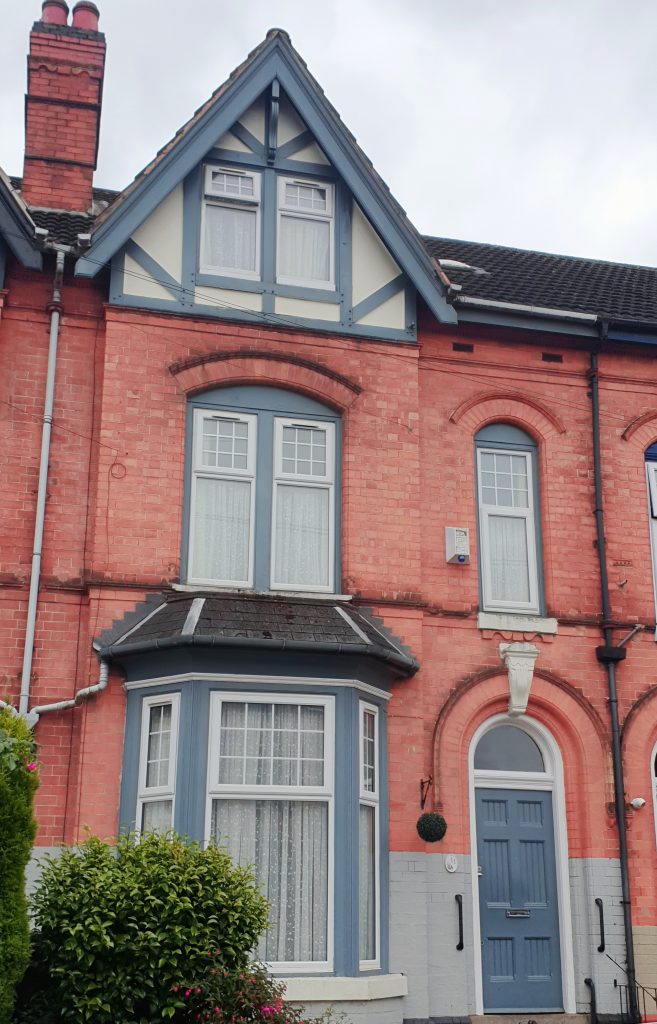
On your left is 11 Edgbaston Road (formerly no. 5), where the widowed second wife of Tolkien’s great-grandfather, Eliza Suffield (1815-1904), ran a boarding house from c. 1891 to 1904.
After walking a further 50 metres along Edgbaston Road, take the first left turn onto Caroline Road and continue 120 metres uphill to the intersection with Augusta Road.
Look to the left, along Augusta Road. Fifty metres on the left is no. 4 (formerly no. 2), which was the first marital home of Tolkien’s paternal aunt Mabel Mitton, according to the 1881 Census. Her husband, Thomas Evans Mitton (1855-1933), whom she had married the previous year, was the owner of a brass foundry.
Now turn right and walk 70 metres along Augusta Road to the junction with Park Road, at which point turn left. Walk 200 metres up Park Road to the junction with the A435 Alcester Road.
Near the corner of Park Road and the Alcester Road is the site of a house called ‘Ivy Lodge’, which was the home of Tolkien’s paternal grandparents in the 1871 Census and therefore his father’s house as a teenager.
Turn right onto the Alcester Road and walk uphill towards Moseley village, as far as the junction with Woodbridge Road and Chantry Road.
On the left is 140 Alcester Road, which was the branch of Lloyd’s Bank where Tolkien’s father worked as a clerk during the 1880s. In 2024, the building houses a restaurant serving Peruvian cuisine.
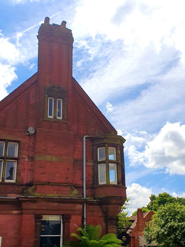
Look up Chantry Road on your right. Visible on the lefthand side of the road is no. 56 (also known as ‘Woodville’), where Tolkien’s eldest maternal aunt Edith May Incledon (1865-1936) and her family lived at the time of the 1901 Census. It was probably in Woodville that Tolkien learnt ‘Animalic’, the secret language invented by his cousins Marjorie May (1891-1973) and Frieda Mary Incledon (1895-1940). Later, he and Mary invented another language called ‘Nevbosh’.
Continue along the Alcester Road through Moseley village for a further 80 metres.
An arched entrance to Moseley Park is on the right, between 93 & 95 Alcester Road. This was part of the grounds of Moseley Hall until 1896, when it became a private park for the residents of the newly built Salisbury Road and Chantry Road, among whom were the Incledons. It is therefore quite likely that Tolkien, living just 400 metres away in the winter of 1900-1901, played with his cousins in the park and saw there the eighteenth-century icehouse. One can imagine him peering through the entrance of the earth-covered structure, wondering what manner of civilised subterranean creature had once dwelt in this brick-lined hole. Moseley Park is open every Wednesday from 10am to 4pm and on the last Saturday of the month.

Proceed along the Alcester Road for 300 metres more, as the road gently curves right and uphill through Moseley, until reaching the point where Tudor Road joins from the left.
On your left is 214 Alcester Road, the site of an end-of-terrace house where Tolkien lived after his mother relocated the family from Sarehole in the autumn of 1900. Her primary motive for moving closer to the centre of Birmingham was to shorten J.R.R. Tolkien’s daily journeys to and from King Edward’s School on New Street. She may also have desired to be closer to her parents and sisters, as well as to St Anne’s Church in Digbeth, where she had secretly been receiving instruction in the Roman Catholic faith. Sadly, the house on the corner has since been demolished. Tolkien remembered it as ‘dreadful’. It must have been shaken and polluted by the steam-trams which passed every few minutes. The Tolkiens’ tenure of the Alcester Road house only lasted for a matter of months, and by the spring of 1901 they were living in a new house less than a mile to the south-west, in King’s Heath.

On your right, opposite 214 Alcester Road, is no. 171, where a second cousin of Tolkien’s mother, Winifred Elizabeth Johnson (née Suffield), lived with her husband’s family at the time of the 1911 Census.
Continue up the Alcester Road for a further 200 metres. If necessary, use the pedestrian crossing to reach the west pavement, enabling you to turn right onto Reddings Road. Walk all the way along Reddings Road (just under 700 metres) to the roundabout at the junction with Moor Green Lane. Continue straight over at the roundabout, following Moor Green Lane for around 350 metres as it bends left, around the cricket pitch. Where Yew Tree Road joins from the left, enter Highbury Park through the gate beside the lodge. Follow the path to the left, which keeps to the outside perimeter of the park, for 200 metres. Upon reaching the corner of Highbury Hall which displays a blue plaque, turn right and walk around to the rear of the building.
Between 1880 and 1914, Highbury Hall was the residence of the Birmingham MP and Colonial Secretary Joseph Chamberlain. In 1901, when its parkland was less arboraceous than today, Highbury would just have been visible to a nine-year-old Tolkien from the rear of his house on Westfield Road, especially at night. Highbury had been one of the first houses in Birmingham to have electric lighting installed. It was one of a half a dozen elevated mansions around Moseley whose memory may have played a part in the creation of Tolkien’s Bag End.
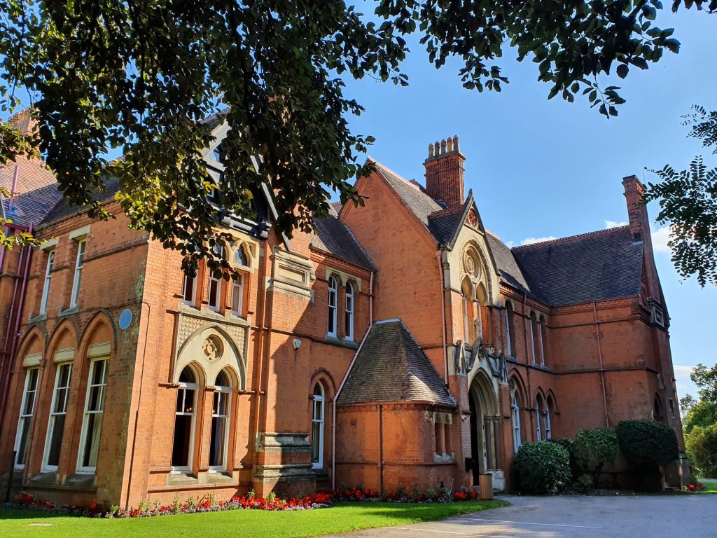
After a 50-metre walk past the rear of Highbury Hall, you face a hedge. Turn right and take the path which leads downhill through the wooded park. Proceed south-eastwards along such paths for 400 metres: turn right at the initial T-junction; curve leftwards; then right again, taking you down some steps and across a footbridge, with a pond on your left; turn right at the next fork and right again upon reaching Highbury Orchard; finally, turn left onto a hard path. Follow this path southwards for 200 metres, until you encounter a tall brick wall, the boundary of a rose garden belonging a lost estate called The Henburys. Before the wall, turn right onto Loverose Way and continue for 250 metres to the car park. Take the path which leaves the car park between the litter bins on its left side and cross 220 metres of open field. Where the path forks in the middle of field, keep right to the exit onto Dad’s Lane/Avenue Road. On reaching Avenue Road, turn left and proceed for 200 metres, under the railway bridge, before turning left onto Station Road. After 90 metres, turn left again onto Highbury Road and then, after another 90 metres, right onto Westfield Road. Walk along Westfield Road for 150 metres.
On your left is 86 Westfield Road, formerly ‘St Malo’, which was Tolkien’s house from early 1901 until early 1902. It was newly constructed at the time, part of a series of terraces built on the estate of a mansion called The Grange. St Malo was large in comparison to the Tolkiens’ preceding residence in Moseley, comprising a drawing room, dining room, kitchen and scullery; however Mabel was not fond of it. Part of the house’s appeal to a young J.R.R. Tolkien seems to have been the Birmingham and Gloucester railway, which runs along a cutting at the bottom of the garden. It is likely that Tolkien was referring to the traffic on this line when he told W.H. Auden that his interest in the Welsh language sprang from reading the lettering on the side of coal-trucks in childhood.
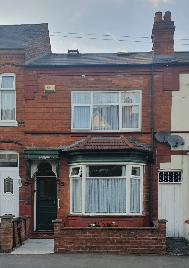
Follow Westfield Road for 230 metres as it turns right and uphill to Station Road.
On the near-right corner of the junction with Station Road is the former site of St Dunstan’s Church, where Tolkien and his family worshipped from 1901 to 1902. The proximity of a Catholic church to 86 Westfield Road had been a major factor in Mabel Tolkien’s decision to move there, however she soon developed a preference for worshipping at the Birmingham Oratory in Edgbaston.
Ahead and to the left, on the far side of Station Road, is the former site of The Grange, an eighteenth-century house demolished in 1895 to make way for the terraces you now see. Tolkien was only three years old when the trees and hedges of the estate were uprooted and its fields levelled, but it’s conceivable that the transformation of the landscape so near to his grandparents’ house left an impression on him. A building called The Grange appears in his fictional Hobbiton and is destroyed during the Scouring of the Shire.
Turn left onto Station Road and walk 50 metres.
On your right is 95 Station Road, which in the 1911 Census was the house of a cousin of Tolkien’s mother. Mark Oliver Suffield (jr.) (1865-1936) attended King Edward’s School and became a successful portrait photographer.
Walk 230 metres to the end of Station Road and at the junction with the A435 Alcester Road, turn left. King’s Heath Station, where this part of The Shire Way finishes, is 150 metres on your left.
NEXT: Stage 1 of The Shire Way